{
"currentVersion": 10.41,
"serviceDescription": "This service was created specifically to work with the Priority Framework Watershed Selection Map.
\n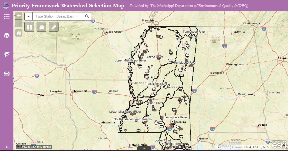 <\/a>
<\/a>
If the 303(d) or TMDL complete data are needed please use the 2016ImpairedWaters map service<\/a>
\n Section 303(d) of the Clean Water Act and the implementing federal regulations at 40 C.F.R. §130.7 require the state to identify those waters within its jurisdiction for which effluent limitations are not sufficient to implement one or more applicable water quality standards and for which Total Maximum Daily Loads (TMDLs) are not yet completed. The state is to establish a priority ranking for such waters, taking into account the severity of the pollution and the uses to be made of such waters. TMDLs are Total Maximum Daily Loads. A TMDL represents the maximum amount of a pollutant that can enter a water body so that the water body will meet and continue to meet state water quality standards. Section 303(d) of the Clean Water Act requires states to identify all waters that are not meeting their water quality standards. For these waters, the state must calculate how much pollution can be put in the water without violating the standard, and then distribute that quantity to all the sources. That quantity is the sum of the point sources plus the nonpoint sources plus a safety factor to maintain the integrity of the water sources. TMDLs serve as planning tools for developing specific controls needed to meet water quality standards. This service contains TMDL Complete segments and Impaired Waters, both linear and polygonal, from the 2016 Active 303d list.
\nFor more information visit the 303(d) / TMDL Page on the MDEQ Website
<\/a> \n
\n
\n303(d) metadata<\/a>\n
\n\nTMDL Complete metadata<\/a>\n
\nData Download<\/a>\n
\nThe Mississippi Department of Environmental Quality makes no warranties, expressed or implied, as to the accuracy, completeness, currentness, reliability, or suitability for any particular purpose of the data contained here in.
",
"mapName": "Layers",
"description": "",
"copyrightText": "MDEQ, The Geospatial Group, BSEGREST, JALLEY, DCOOK",
"supportsDynamicLayers": false,
"layers": [
{
"id": 0,
"name": "2016 303d Impaired Waters",
"parentLayerId": -1,
"defaultVisibility": true,
"subLayerIds": [
1,
2
],
"minScale": 0,
"maxScale": 0
},
{
"id": 1,
"name": "Stream",
"parentLayerId": 0,
"defaultVisibility": true,
"subLayerIds": null,
"minScale": 0,
"maxScale": 0
},
{
"id": 2,
"name": "Lake",
"parentLayerId": 0,
"defaultVisibility": true,
"subLayerIds": null,
"minScale": 0,
"maxScale": 0
}
],
"tables": [],
"spatialReference": {"wkt": "PROJCS[\"MSTM\",GEOGCS[\"GCS_North_American_1983\",DATUM[\"D_North_American_1983\",SPHEROID[\"GRS_1980\",6378137.0,298.257222101]],PRIMEM[\"Greenwich\",0.0],UNIT[\"Degree\",0.0174532925199433]],PROJECTION[\"Transverse_Mercator\"],PARAMETER[\"False_Easting\",500000.0],PARAMETER[\"False_Northing\",1300000.0],PARAMETER[\"Central_Meridian\",-89.75],PARAMETER[\"Scale_Factor\",0.9998335],PARAMETER[\"Latitude_Of_Origin\",32.5],UNIT[\"Meter\",1.0]]"},
"singleFusedMapCache": false,
"initialExtent": {
"xmin": 129572.60439740279,
"ymin": 1240180.7176948052,
"xmax": 853394.1424025972,
"ymax": 1603429.4193,
"spatialReference": {"wkt": "PROJCS[\"MSTM\",GEOGCS[\"GCS_North_American_1983\",DATUM[\"D_North_American_1983\",SPHEROID[\"GRS_1980\",6378137.0,298.257222101]],PRIMEM[\"Greenwich\",0.0],UNIT[\"Degree\",0.0174532925199433]],PROJECTION[\"Transverse_Mercator\"],PARAMETER[\"False_Easting\",500000.0],PARAMETER[\"False_Northing\",1300000.0],PARAMETER[\"Central_Meridian\",-89.75],PARAMETER[\"Scale_Factor\",0.9998335],PARAMETER[\"Latitude_Of_Origin\",32.5],UNIT[\"Meter\",1.0]]"}
},
"fullExtent": {
"xmin": 334484.3329,
"ymin": 1062570.1647,
"xmax": 648482.4139,
"ymax": 1577674.2167,
"spatialReference": {"wkt": "PROJCS[\"MSTM\",GEOGCS[\"GCS_North_American_1983\",DATUM[\"D_North_American_1983\",SPHEROID[\"GRS_1980\",6378137.0,298.257222101]],PRIMEM[\"Greenwich\",0.0],UNIT[\"Degree\",0.0174532925199433]],PROJECTION[\"Transverse_Mercator\"],PARAMETER[\"False_Easting\",500000.0],PARAMETER[\"False_Northing\",1300000.0],PARAMETER[\"Central_Meridian\",-89.75],PARAMETER[\"Scale_Factor\",0.9998335],PARAMETER[\"Latitude_Of_Origin\",32.5],UNIT[\"Meter\",1.0]]"}
},
"minScale": 0,
"maxScale": 0,
"units": "esriMeters",
"supportedImageFormatTypes": "PNG32,PNG24,PNG,JPG,DIB,TIFF,EMF,PS,PDF,GIF,SVG,SVGZ,BMP",
"documentInfo": {
"Title": "",
"Author": "",
"Comments": " Section 303(d) of the Clean Water Act and the implementing federal regulations at 40 C.F.R. ยง130.7 require the state to identify those waters within its jurisdiction for which effluent limitations are not sufficient to implement one or more applicable water quality standards and for which Total Maximum Daily Loads (TMDLs) are not yet completed. The state is to establish a priority ranking for such waters, taking into account the severity of the pollution and the uses to be made of such waters. TMDLs are Total Maximum Daily Loads. A TMDL represents the maximum amount of a pollutant that can enter a water body so that the water body will meet and continue to meet state water quality standards. Section 303(d) of the Clean Water Act requires states to identify all waters that are not meeting their water quality standards. For these waters, the state must calculate how much pollution can be put in the water without violating the standard, and then distribute that quantity to all the sources. That quantity is the sum of the point sources plus the nonpoint sources plus a safety factor to maintain the integrity of the water sources. TMDLs serve as planning tools for developing specific controls needed to meet water quality standards. This service contains TMDL Complete segments and Impaired Waters, both linear and polygonal, from the 2016 Active 303d list. \nFor more information visit the 303(d) / TMDL Page on the MDEQ Website\n\n303(d) metadata\n\n\nTMDL Complete metadata\n\nData Download\n\nThe Mississippi Department of Environmental Quality makes no warranties, expressed or implied, as to the accuracy, completeness, currentness, reliability, or suitability for any particular purpose of the data contained here in. \n",
"Subject": "Mississippi 2016 Sec 303(d) list of Impaired Waters",
"Category": "",
"AntialiasingMode": "None",
"TextAntialiasingMode": "Force",
"Keywords": "MS303d,Impaired Water,Clean Water Act Section 303d"
},
"capabilities": "Map,Query,Data",
"supportedQueryFormats": "JSON, AMF, geoJSON",
"hasVersionedData": true,
"exportTilesAllowed": false,
"maxRecordCount": 1000,
"maxImageHeight": 4096,
"maxImageWidth": 4096,
"supportedExtensions": "FeatureServer"
}